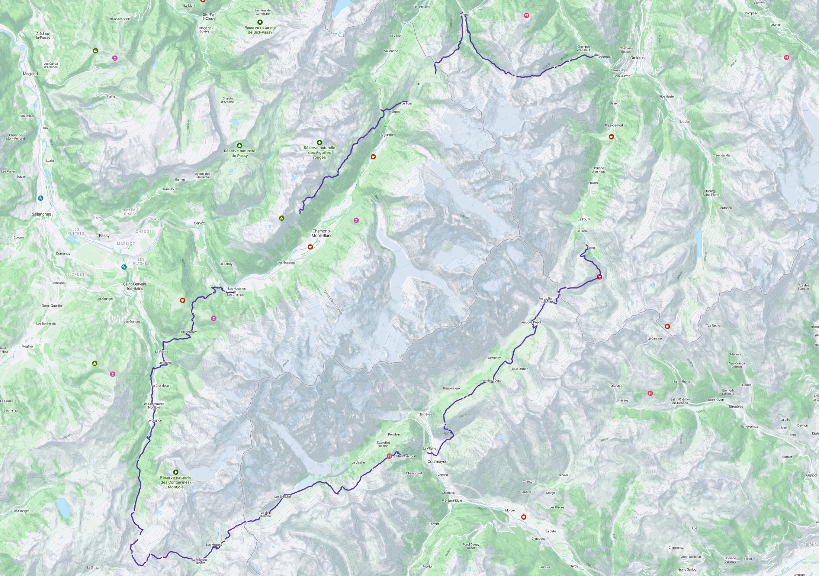
The Tour du Mont Blanc is a an approximately 165km trail around the Mont Blanc massif, starting and ending in Chamonix, France while crossing through France, Italy and Switzerland. Traditionally, it’s hiked counter-clockwise. Why? I don’t know. At the end of August, it becomes the route of the most famous trail running event “UTMB (Ultra Trail du Mont Blanc)” and the top runners run the loop in under 20h - kaputt.
Our Hike in 8 Days
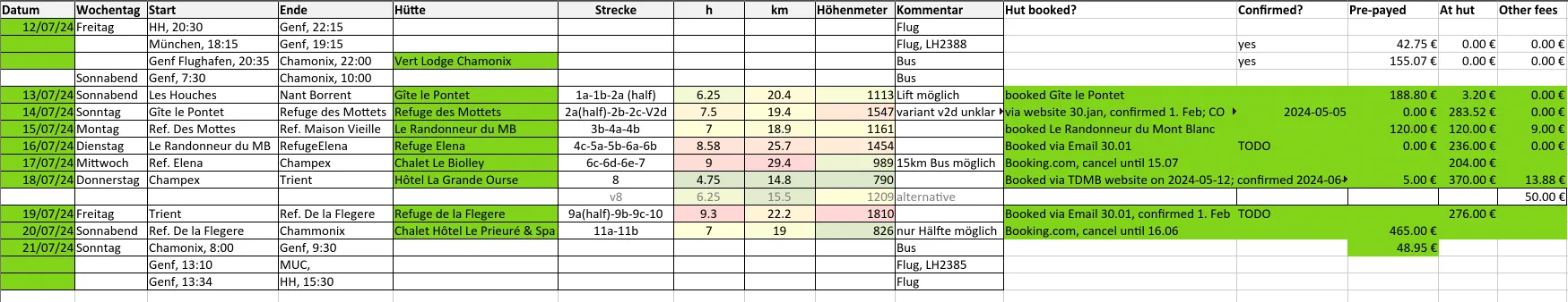
We hiked the trail as a family of four people in mid-July (12.07 - 21.07.2024). As luck would have it, we never experienced inclement weather or even rain at all (save for one breakfast). That is apparently rare.
Note: we didn’t do the entire trail, but took a few bus/gondola shortcuts and stopped in Chamonix rather than the start point of Les Houches.
Total statistics:
61h total time (including breaks)45h45min moving time9522m ascended7004m descended132.11km distance hiked
Planning & Booking the Huts
I booked all the huts in January 2024 and was able to get a spot at most of the huts we wanted to stay at. For others, there were good alternatives close by. If you are a group of more than two people, I’d recommend reserving in December the year before already just for the peace of mind. I was a bit late. If you don’t get one or two huts immediately, don’t panic. There are a bunch of cancellations so it pays off to check back frequently. Also, you can make “emergency” bookings though e.g. booking.com which can be cancelled for free up until a few weeks before the hike. I had some lined up until all the huts were confirmed, otherwise we’d taken the bus to the next village and back for one or two nights. Not ideal, but entirely possible.
The Route
Day 0: Munich to Chamonix
We flew by plane from Munich to Geneva and took a shuttle bus from the airport to Chamonix. The ride took approx. 1h15min with Swiss Bus. We managed to get some food from the Migros supermarket at the airport, but, eating it was strictly prohibited on the bus :( - we ate it at our lodge. Slept at Vert Lodge in Chamonix, which has simple but good rooms and is a 15min walk from Central Chamonix Bus stop. We had to walk because of our late arrival. However, right in front of the Vert Lodge is the local bus stop towards Les Houches.
Day 1: Les Houches to Gîte le Pontet (Les Contamines)
Start: 8:45h Total Time: 8h15min Moving Time: 6h Distance: 20.61km Elevation Change: ⬆️1109m ⬇️879m Strava link: https://www.strava.com/activities/11880319668
Woke up early, had some basic breakfast at the lodge and waited for the bus to Les Houches to arrive. Surprise, we successfully met the other two from Hamburg on the bus - it worked out perfectly. We arrived in Les Houches and had a quick 2nd breakfast, which was a lot better! Can recommend the bakery Eric Jacquier there for some coffee and a croissant! Fed, we started off strong towards the TMB sign to take a group picture before continuing on to the first climb. Up the Kandahar ski slope to Col de Voza. They used lost ski poles as fence posts - cute! We opted against doing the Col de Tricot variant - it’s only the first day and best not to overdo it. Turned out to be the correct decision, as the additional elevation would’ve been tough! We descended from the Col de Voza and opted against having lunch there, luckily. Filled up our bottles though at the railroad tracks. After approx. 20mins, we passed the Refuge du Fioux with an absolutely stunning view and opted to have a quick lunch there on their terasse. The omlett and blueberry cake seemed to be the go-to dishes there but we didn’t realise until later and made do with four coffees, a cheese plate and salad for only 31€. Highly recommend this place for lunch! The trail winds down back into the valley through beautiful, small villages. Lots of flowers greeted us in full bloom. There was a small detour, which is the official TMB but seemed a bit off: From the valley, we climbed again towards La Gruvaz up the eastern slope just to cross a river coming down from the peaks above. Could’ve just gone along the road, but alas, this was the trail. Once back in the valley, we crossed the road in Le Quy and treaded steadily upwards along the river towards Les Contamines. Les Contamines turned out to have a fantastic supermarkets, a Carrefour Montane with a sublime selection of snacks and fresh fruit. With our empty stomach, we of course bought way too much, but we were just 30mins from our spot for the night away anyway. Once we arrived at the camp site, we checked in, indicated that we wanted a vegetarian meal, which was easily accommodated for, chose our bunks for the night and took a shower. The Tour de France was shown before dinner in the common area, where tired hikers lounged with a beer. The food was spectacular, one of the best dinners of all the places we stayed at. Three course menu with refills available for the main course. Melon, curry, chocolate brownies served in a recently renovated dining hall hut. Initially, I planned to go to the Nant Borrent hut today but it was fully booked already. On the next day, it took us approx. 1h of climbing until Nant Borrent after a fresh night of sleep. That would’ve been really hard today. We felt lucky to have stayed here.
Day 2: Gîte le Pontet to Refuge des Mottets
Start: 8h30
Total Time: 9h45min
Moving Time: 7h
Distance: 19.82km
Elevation Change: ⬆️1613m ⬇️956m
Strava link: https://www.strava.com/activities/11892407949
Over the previous days, I wasn’t sure whether the variant over the Col du Fours was already passable. I frantically checked instagram, reddit, strava and mountain reports for reports from previous hikers to attain if descending the Col is doable without taking significant risks. On the start of the day, I was pretty confident that we would be able to do Col du Fours, but won’t do the unofficial Col d’Enclave variant. The internet was adamant about even the Col du Fours being too dangerous, but I could see on strava for example that lots of people have passed there (Strava route to check: https://strava.app.link/xgB0PTr95Kb ). On reddit, where mostly Americans post, the opinion was clear that it was absolutely impossible to pass. We would see.
The initial part up from Le Pontet to Nant Borrent was steep but through a forest, so we could remain cool for a bit longer.
- first view of mont blanc - insane vista from col du fours
- looong way down
- fromage at the bottom
- nice hut, with good food. good showers
- no cell signal from col du fours until the hut! they have a french phone you can use and starlink, but only for emergencies!
Day 3: Refuge des Mottets to Le Randonneur du Mont Blanc
Start: 8h30
Total Time: 8h45min
Moving Time: 5h45min
Distance: 19.08km
Elevation Change: ⬆️1172m ⬇️1124m
Strava link: https://www.strava.com/activities/11895350637
- stunning vista to wake up to, ville de glaciers
- very windy col de la seigne
- passing Rifugio Elisabetta
- lots of day trekkers / school classes / mountain bikers up until elisabetta
- brutal climb back up at rifugio combal
- great food, showers payed - need extra coins but clean
- slight rain in the evening
Day 4: Le Randonneur du Mont Blanc to Rifugio Elena over Courmayeur
Start: 8h30
Total Time: 10h30
Moving Time: 6h30
Distance: 22.53km
Elevation Change: ⬆️1626m ⬇️948m
Strava link: https://www.strava.com/activities/11912049665
- took the cable car down to courmayeur
- bought fromage (really good store), jogurth, bread, and sunscreen. had a 2nd breakfast
- took the upper Val Ferret variant - was the right call
- steep climb up to Rifugio Bertone through the forest. Lots of day tourists. Don’t stop at the Rifugio if there’s good weather - go a bit further to see Monte Bianco
- Along the Val Ferret insane views of Monte Bianco and the Grand Jorasses
- Rifugio Walter Bonatti looked really nice
- From Calet Val Ferret to Elena brutal climb at the end of the day. Great view though
- Arrived a bit late, at 19h.
- Elena is clean, bad food and worse service. close hut down at like 21h - can’t sit anywhere and cannot go outside.
Day 5: Rifugio Elena to Champex-Lac over Ferret / Orsieres
Start: 8:30
Total Time: 5h15
Moving Time: 3h30
Distance: 10.97km
Elevation Change: ⬆️636m ⬇️970m
Strava link: https://www.strava.com/activities/11912051894
- easy day
- contemplated a variant - but didn’t do it
- go up for view on the col though
- many mountain bikers, cows
- took bus from Ferret to Orsieres. went shopping
- slept at Chalet half way up to Champex Lac, went there by bus.
- Cosy chalet, were able to wash clothes, cook, shower - one of the best stays so far!
Day 6: Champex-Lac to Trient over Fenêtre d’Arpette
Start: 8h15
Total Time: 9h30
Moving Time: 6h15
Distance: 16.16km
Elevation Change: ⬆️1206m ⬇️1408m
Strava link: https://www.strava.com/activities/11921499082
- took bus to champex lac
- tasty bakery at the lake, loaded up on bread
- weren’t entirely sure of the conditions of the arpette variant - but did it based on
- good weather
- reports that it had been done (checked strava)
- scouting by fernglass
- scorching hot climb up with little tree cover
- helicopter moved overhead a lot
- not much water on the trail, one Quelle after leaving river and until top
- last 3rd is scrambling over block gestein, also very steep. but rewarding
- going over the col, breathtaking view of glaciers
- way down is nice, can’t stop turning around and looking at the glaciers one more time
- reach Buvette du Glacier du Trient after some time. from there it’s still quite a bit until the city of trient. stunning path with a creek laid right along side it - the watersupply for trient? makes the trail chilly and comfortable to walk along
- trient lies beautifully, small town.
- great hotel we stayed at. gave 2 dinners. nice outdoor chill area. expensive - but switzerland
- meant to stay refuge du col de la balme initially, would’ve been one more brutal climb, but worth it?
Day 7: Trient to Refuge La Flégère
Start: 8h30
Total Time: 8h45
Moving Time: 6h15
Distance: 17.36km
Elevation Change: ⬆️1854m ⬇️536m
Strava link: https://www.strava.com/activities/11929894346
- climb up from trient nice in the shade
- huge group of americans with us who were brought to the trail head by taxi and weren’t carrying their packs. bit annoying but OK
- alpenrose
- on arrival at col de la balme, incredible vista of the mont blanc and adjacent mountains. best view of mont blanc yet
- great food at the hut, ate yogurth, brownie, etc
- took the cable car down to le tour instead of hiking down. was the right choice (judging by our time of arrival), but the variant way down would’ve been beautiful as you view the valley with mt blanc all the way
- cross the big street, back in civilization
- up towards the ladders
- ladders were not that problematic, nice break, saw goats!
- long trail until flegere. flegere lies beautifully - old hut right beneath a huge ski station. but from the hut, the ski station is invisible and you have the perception of being alone in the nature.
- best hut staff yet, very accomodating. with extra food, etc. great food!
- at dinner booked the cable car for aguile du midi for the next day. tickets did appear and disappear quickly - so keep on checking the web portal.
- incredible sunset - sun on mont blanc, grande jorasses, glaciers. best sunset yet. could stay outside after hut closing hours to take pics of the stars. saw many headlamps of people climbing in the mountains. stunning !
Day 8: Refuge La Flégère -> Brévent
Start: 8h45
Total Time: 1h45
Moving Time: 1h45
Distance: 5.42km
Elevation Change: ⬆️339m ⬇️187m
Strava link: https://www.strava.com/activities/11937922595
- short hike over to the cable car
- had a nice tee and snack there
- took the cable car down to chamonix, leave stuff at hotel
- take cable car up to aguile du midi
- took cable car over to punta hellbronner - by far the most impressive thing about the cable car - absolute must do for round trip of 40eur (vs 39eur one way)
- good dinner in the city
Day 9: Chamonix to Muc
- bus in the morning to Geneve, breakfast there
- to the airport, very close to the city
- fly
Planning the Hike
- know possible exit points
- know shortcuts, e.g. via cable car
- know refuelling points
Best Huts
-> section useful?
Links
- bus transport along the route
- booking huts
- good description of the huts and how to book them here
- good tips on how to book huts2, bus shortcuts to les champieux explained here
- pinch points to book first, from the book
- experience / maps
- trail conditions (ATTENTION, they are OVERLY CAUTIOUS!!). better: check strava or instagram for recent activities and judge by yourself :)
- Chamomix high mountain office snow forecast: https://www.chamoniarde.com/en/mountain-topics/mountain-conditions
- Unofficial variant on day 2 to go to mottets over col d’enclave: https://michael-l.livejournal.com/4350.html -> too much snow for us to do it!
- Trail conditions blog 1: https://montblanctreks.com/news
- New Strava heatmaps might also be good to find new route information: https://www.strava.com/clubs/231407/posts/33475575
